― KEUKA LAKE STORY ―
Keuka Lake is situated in the Finger Lakes region of New York State at an elevation of 715 feet above sea level. It is 19.6 miles long, 3/4 of a mile wide, on average, and has a surface area of approximately 18 square miles. Overall, it has been estimated that the lake holds approximately 379 billion gallons. Contributing to the water in the lake is a watershed that covers 110,000 acres spanning 10 towns and two villages in Yates and Steuben Counties. Six of those towns and the two villages have lakeshore frontage. The watershed has approximately 20,000 people living in roughly 6,300 homes, 2,900 of them are located on the lake.

The Human History Around Keuka Lake
The Keuka Lake watershed was settled by people almost as soon as the Ice Age ended, some 9,000 years ago. These first people supported themselves by hunting, fishing and gathering wild food. Archaeological remains from the vicinity of Lamoka Lake reveal their diet of deer, turkey, passenger pigeon, bear, turtle, bullhead and the acorns from white oak trees.
Agriculture first appeared in the area nine hundred years ago with the Owasco people who brought the "Three Sisters" agriculture of interplanted corn, beans and squash. Early European explorers of the Keuka Lake watershed encountered the Iroquois, a group who are thought to have arrived five hundred years ago. The Seneca tribe of Iroquois remained in the area until they were driven out by colonists following the Revolutionary War. The Seneca called the area "O-go-ya-ga", which translated as "the promontory" and probably referred to Bluff Point. Other sources claim that "Keuka" can be interpreted as "bent elbow".
In 1770, the area was almost completely covered with forest. The original forests were mainly sugar maple, beech, hickory, red and white oaks, tulip poplar and black walnut. On the higher hills and ridges, white pine were common. Chestnut, white ash, butternut and basswood grew on the drier sites. In the valleys, elm, black ash, willow, poplar, and soft maple were common. Hemlock and gray birch grew in more shaded areas such as gullies.
In 1787, a committee from Rhode Island representing Jemima Wilkinson, the "Public Universal Friend", visited the area between Seneca and Keuka Lakes looking for land for their sect's new home. They found several colonists the Senecas had permitted to reside in the area. The committee was pleased by what they saw, and within two years moved more than sixty families of Wilkinson's followers into the area. They purchased deeds to their land from Charles Williamson, the land company agent located in Bath who had great influence over the whole area. Williamson contributed the name "Esperanza" to Bluff Point. Wilkinson's followers began by erecting dams and mills on the Outlet and a second colony led by the Potter family built on Sugar Creek, north of the present site of Branchport.
In the early nineteenth century, there was strong competition for most favorable locations for production and trade. "Summersite", an alternative to early Penn Yan, grew up to the south of the Outlet along the lakeshore. In 1809, the first published reference to "Pen Yang" appeared in local papers. The name aptly represents the meeting of influences from Penn's colony to the south and from the Yankees moving in from the east.
The 1830s were important years for Penn Yan and the lake. Penn Yan incorporated as a village in 1833, and in the same year the Crooked Lake Canal, which paralleled the Outlet, opened. Agricultural produce of the area could be floated through the 28 locks of the canal to reach Seneca Lake and the Erie Canal system. In 1836, the first vineyards in the Keuka Lake watershed were planted by J. W. Prentiss of the Town of Pulteney. In 1837, the first steamboat, the "Keuka", began hauling passengers and produce on Keuka Lake. Traffic moved both north and south and produce destined for Penn Yan could be transferred to barges on the Crooked Lake Canal or to cars on the Fallbrook Railroad, which connected with the New York Central system. Produce carried to Hammondsport would be hauled by teams through Pleasant Valley to Bath where it would be floated down the Cohocton River on rafts or, later, loaded onto the Lehigh Valley Railroad. The steamboats were crucial for moving agricultural produce to market, and severeal more graced the waters of Keuka including: Steuben, George R. Young, Keuka, Yates, Lulu, Urbana, Farley Holmes, William L. Halsey, West Branch, Mary Bell, and the Cricket. Docks and piers were built in Penn Yan, Branchport and Hammondsport to move the produce from lake to land transport. Large icehouses at the ports stored ice cut from the lake used to cool shipments to distant markets. Several steamboats operated into the 1920s for tours and excursions, but automobiles and good roads replaced them for other purposes.
From 1840 until the turn of the century, there was a boom in the production of grapes, first for fresh eating and later for wineries. By 1900, more than 10,000 acres of vineyards producing 15,000 tons of grapes each year ringed Keuka Lake in a band half a mile wide and 50 miles long. In 1861, Charles D. Champlin established the first winery of the area, the Pleasant Valley Wine Company. Others such as Taylor (1880) and Empire (1896) followed.
The height of agricultural production occurred before the turn-of-the-century. There has been a gradual decline in agriculture since then, with only about half as much land worked now (approximately 31,000 acres). Obviously the vineyards and wineries were severely hurt by Prohibition and the Depression.
At the same time that agriculture was declining, tourism and recreational uses of the lake increased dramatically. In the 1850s, the old "Keuka" steamboat grounded south of Penn Yan was converted into The Ark, the first resort on the lake. In the 1870s, the first summer cottages were built on the lakeshore - some were accessible only by steamboat, others could be reached by roads or by the electric trolley running between Penn Yan and Branchport. The 1880s saw the growth of retirement homes on the lakeshore as well as the establishment of Keuka College, the Keuka Lake Sanitarium, and other spas. In 1885, electric power generated by the Outlet began lighting the Village of Penn Yan, and common usage had changed the name of the lake from "Crooked" to "Keuka".
In the 1890s, competing steamboat companies carried more sightseeing passengers and less freight, numerous nature-study camps were established, and Electric Park, an amusement park on the Bluff, began operation.
After the turn-of-the-century, several industries sprang up in the Keuka Lake Watershed: Curtiss Aircraft in Hammondsport (1910) and Penn Yan Boat (1921). Glenn Curtis' 1908 flights in Red Wing and the June Bug were made from the ice of Keuka Lake. The success of automobiles and the growth of a modern road system changed the way Keuka's shore was developed. In 1938, NYS Route 54 was moved away from the eastern shore of the east branch to provide more room at the shoreline for residential development. Summer homes were constructed on the west sides of both northern branches, and several large tracts such as The Pines were subdivided.
Since the 1920s, much of the shoreline of the lake has been developed for cottages and second homes. Recent trends include development of steep or wet sites, conversion of summer homes to year-round use, demolition and rebuilding of structures, and development of woodland and lake-view parcels. The density of development and the existing utilities and services around the perimeter of the lake have resulted in an "urban corridor" surrounding the lake. The rate of development has been increased by the lake's proximity to urban centers and the availability of good highways. Development pressure on the land currently used for agriculture has increased.
There are no longer any virgin timber stands remaining in the watershed. The present forests consist of second-growth stands of the original species, with chestnut and elm missing as a result of disease, and locust and spruce added. Most of the remaining mature forests are on wet or steep sites. The forested areas of the watershed, especially on the steeper slopes to the south, provide many water quality benefits including stormwater retention and erosion control.
Geology of the Keuka Lake Bedrock Geology
The bedrock of the Keuka Lake watershed consists of sedimentary rocks deposited as part of the extensive Catskill Delta from 375-360 million years ago during the Middle and Upper Devonian Period. At that time, most of the area was a shallow sea. For the next 325 million years, sediments from mountains to the east washed into the basin. Eventually the sediments were compressed and hardened to form the various rock formations we see exposed in the gorges and gullies throughout the region.
Today this region is part of the hilly, glaciated Appalachian or Allegheny Plateau. Bedrock here consists largely of sandstones, siltstones and shales of the Genesee, Sonyea, and West Falls groups. The Genesee Group is composed mostly of black petroliferous shales exposed in stream valleys in the northwestern portion of the watershed and many gray silty shales and siltstones in the vicinity of the Village of Penn Yan. The Sonyea Group consists predominately of light to very dark gray shales and interbedded siltstones, and forms the steep slopes of Keuka Lake south of Penn Yan and Branchport. The hill top of the Bluff, the hills between Hammondsport and Bath, and ridges on either side of the lake are underlain by the West Falls Group, a series of interbedded gray shales, mudstones, silty shales, and siltstones. All these rocks dip gently to the south and west with an overall thickness exceeding 2,300 meters.
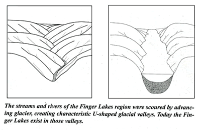
Following the deposition of the bedrock, the Allegheny Plateau was uplifted and eroded by streams which mainly drained southward reaching the Atlantic Ocean through the Susquehanna River system. The southward drainage of Keuka Lake is confirmed by the Y-shape of the lake as well as the fact that the valley becomes wider in that direction. Geologists explain the region's character as the result of two separate and different ice events: the Kansan and the Wisconsinan glaciers. The Kansan glacier flowed over the region about a million years ago and is considered to be responsible for the major changes in the landscape that we see today. The Wisconsinan glacier, which withdrew 13,000 years ago, followed some of the same paths as the Kansan but left behind rock deposits such as drumlins (small mounds of deposited material resembling an upside-down spoon), eskers, moraines, kames (conical hills of sand and gravel deposited by glacial meltwater), and erratics (boulders transported by the glacier) that are still important parts of our landscape. The mile thick ice exerted overwhelming force on the bedrock formations below. The immense weight of the glaciers caused the ground below to sink, forming a depression. Large blocks of rock from the sedimentary formations were extracted from the bedrock through a process called "plucking". The erosive power of the glaciers increased as the southward flowing ice collected and transported rock debris which scoured the landscape. These three glacial actions deepened, widened, and straightened the existing stream beds giving them the characteristic U-shape of glacial valleys.
When the southern edge of the Kansan glacier stabilized just south of what is now the Finger Lakes, it deposited a steep, linear ridge of unsorted, unstratified glacial till known as the Valley Heads Moraine. This moraine effectively dammed the southward flowing streams creating Keuka and most of the other Finger Lakes, including Canandaigua, Seneca, and Cayuga. In addition, this moraine today acts as a drainage divide separating streams which flow to the Atlantic via either the Great Lakes and St. Lawrence Seaway or the Susquehanna River Basin. The exception is the Genessee River which cuts through the moraine from the south, flowing north into Lake Ontario. Today, Keuka Lake drains through the Outlet at Penn Yan about eight miles into Seneca Lake, hence to Lake Ontario via the Seneca and Oswego Rivers, a route taken by all seven of the eastern Finger Lakes (from Canandaigua Lake eastward.)
Surficial Geology And Soils
Recent mapping of the surficial geology of the Finger Lakes Region details six types of surface conditions within the Keuka Lake watershed. At the northwest and south ends of the lake are broad bands of fairly productive lacustrine (lake) silts and clays, as well as deposits of unoxidized organic (muck) and alluvial materials which are generally located along the swampy lowlands of Sugar Creek, north of the village of Branchport, and Keuka Inlet at Hammondsport. Most of the upland areas of the watershed are covered with unsorted glacial till deposits (ground moraine.) Thickness of the till ranges widely from a few feet to tens of feet. In many places the till is completely absent and the bedrock is exposed. Glacial outwash or sand and gravel materials that have been stratified and sorted by meltwater (kames, eskers, kame terraces etc.), are found along Sugar Creek north of Branchport, and in the valley between Hammondsport and Bath, as well as an abandoned valley that was located between the village of Keuka Park and Keuka State Park. Steep bedrock valleys located along tributary streams of Keuka Lake are underlain by unconsolidated materials classified as "eroded soil on steep and broken lands."
Topography
The Keuka Lake watershed lies within the glaciated (Allegheny) portion of the Appalachian Plateaus Physiographic Province. This region is characterized by broad, straight U-shaped valleys with steep slopes which project upwards for several hundred feet and are capped by rounded or gently rolling hilltops. Hillsides are severely dissected by steep walled valleys, with slopes often exceeding 45%, particularly along the Bluff and western shores of Keuka Lake. The northern portion of the watershed has much lower elevations and slopes. Elevations increase from near 1,000 feet above mean sea level at Penn Yan and Branchport to almost 2,000 feet along the southern edge of the watershed. The mean elevation of Keuka lake is 714 feet above sea level but varies seasonally.
A north-south line halfway between Seneca and Cayuga Lakes separates the province of the Finger Lakes "east" from that of the Finger Lakes "west". The common characteristic of western Finger Lakes is the branching Y form with the broad stem of the Y directed to the south. The creation of the lake basins of the Finger Lakes "west" was caused by down-valley glacial erosion. The east branch of Keuka Lake is one example of this formation.
Keuka Lake's Natural Resources
Keuka Lake is also an enormous recreational resource for swimming, boating, and fishing. There is one state park on the lake along with several public and private boat launches and swimming areas. There are about 2,900 shoreline residences along the 70 mile perimeter of the lake that take advantage of the lake's resources.
The fishery in Keuka Lake is considered the best in the region. The lake has a natural lake trout spawning population as well as large populations of brown and rainbow trout. Other species include landlocked salmon, largemouth bass, pickerel, and various panfish.
Zebra mussels were first sighted in Keuka Lake in the summer of 1994 during routine lake monitoring. A low concentration of young zebramussels, or veligers, were found but no adults mussels were found. By 1996, zebra mussels were found in low concentrations around the entire lake. Presently, it is not known what impact the mussels will have on the fishery or other uses of Keuka Lake. It has been estimated that the zebra mussels will expand and encrust on most hard surfaces in the next few years. The levels of algae in Keuka Lake are relatively low and may not support a large zebra mussels population. However, the amount of algae production is similar to that of Seneca and Canandaigua Lakes where the growth of zebra mussels has been quite vigorous.
Water Testing and Limnology
Since the early 1970's there have been several groups and individuals studying the waters of Keuka Lake. Initially, students and faculty from Alfred State University and Cornell University were the primary researchers. In the 1980's the Keuka Lake Association (KLA) became involved with sampling out of concern over water quality. The project now involves a number of organizations and volunteers testing a variety of parameters in the lake and streams. Cooperating organizations that play a role in the monitoring of Keuka Lake include: Keuka Lake Association, Cornell Cooperative Extension-Yates County, Soil and Water Conservation Districts-Yates and Steuben County, Department of Environmental Conservation, Villages of Penn Yan and Hammondsport, Brockport University, and Cornell University.
The monitoring results for Keuka Lake over the past five years are revealing a clearer picture of the water quality conditions of the lake. The overall lake's health in terms of nutrients, water clarity, plankton, and fish production is excellent. Test results indicate the lake is at or near excellent conditions for total phosphorus, secchi disk (water clairity), and chlorophyll a (an indicator of algae production) in the deep sections of the lake. Phosphorus is the nutrient primarily responsible for algae growth and is needed to support the food chain in the lake. Too much phosphorus results in excessive algae growth and premature "lake aging" or eutrophication.
Secchi disk readings are used to determine the overall clarity of water. A black and white disk is lowered until not visable. The depth of the disk when first seen as it is slowly raised from the depths is recorded. Clearer water results in greater secchi depths and generally indicates better water quality. Water too clear, however, may mean little algae and microscopic animals to support the food requirements of larger animals in the food chain. Low secchi disk depth can be due to heavy sediment loads from storm water runoff in the watershed, algal blooms, and a variety of other causes. Keuka Lake is blessed with a good balance between good water clarity and algae production to support an excellent native lake trout fishery.
Fecal bacteria monitoring results for 1988-1996 indicate excessive bacteria in the lake during the summer, particularly July and August when the summer population is the highest. The most probable source for fecal contamination in the lake is failing septic systems and/or wastewater from boats. The activities of the Keuka Watershed Improvement Cooperative (KWIC) in cooperation with the residents in the watershed - the inspection, pumping, repair and replacement of failing septic systems around the lake - is vital to correcting this problem.
In addition to the fecal counts, shallow water areas experience reduced water quality conditions in the spring, after rain storms, and areas in close proximity to stream outlets. While some of the sediments, nutrients, and other contaminants entering the lake during these periods may be from natural erosion of streambanks, perhaps a larger amount of "preventable" erosion and nutrient transport enters the lake. The testing program to date is not structured to determine and assess specific other "upland" sources, but future research efforts will be directed to understand these important impacts on Keuka Lake.
Total phosphorus (TP), secchi disk and chlorophyll a levels for Keuka, Canandaigua and Seneca Lakes are very similar. Keuka had the highest total phosphorus average of the three, however, the difference from the other lakes was negligible. The Seneca Lake TP results for 1994 are very interesting and appear to reflect the influence of an expanding zebra mussel population. The TP level for 1994 was half of that found in 1992 while secchi disk readings increased 2 meters over those found in 1993 to 6.3 meters. There was another 2 meter increase in secchi disk depth in 1995. One possible explanation for the apparent decrease in phosphorus levels and increase in secchi disk depth is the presence of zebra mussels filtering algae out of the water column thus removing phosphorous from the water. Without phosphorous, fewer algae grow, leading to an even clearer lake (not necessarily a good thing, see secchi disk above). The secchi disk transparency readings indicate that Canandaigua Lake may also be clearing due to the zebra mussels. One years worth of data is not enough to be sure but the 3+ meter increase in secchi disc reading is a good indication.
Helping Protect Keuka Lake
There are several organizations that are working to help maintain the quality of Keuka Lake. These include the Keuka Lake Association (KLA) and the Keuka Watershed Improvement Cooperative (KWIC). These organizationsare committed to helping to improve and maintain the quality of Keuka Lake.
The Keuka Lake Association was originally formed in 1956 as the Keuka Lake Shoreline Property Owners. In 1989, the Keuka Lake Shoreline Property Owners was reorganized into The Keuka Lake Association (KLA). The KLA is a non-profit organization dedicated to the protection and preservation of Keuka Lake and its watershed. The membership of about 1,700 composed of individuals and businesses who have an interest in the quality and protection of Keuka Lake.
The major activity of KLA is the development of a cooperative and uniform approach to managing the environmental quality of the Keuka Lake Watershed. This program is being funded through the Keuka Lake Foundation, Inc., the charitable arm of the KLA. A combination of private and governmental sources support the program.
The Keuka Watershed Improvement Cooperative (KWIC) is an intermunicipal agreement between eight municipalities that provides comprehensive planning for uniform regulation of wastewater (septic) management and assist with uniform enforcement of those regulations within the participating municipalities. The KWIC is also responsible for responding to other problems that threaten the quality of Keuka Lake. The KWIC also has the ability to develop model ordinances and recommendations that local government can take action on to help protect lake water quality. The KWIC may also determine if other methods, such as educational programs, are necessary to promote water quality.
The KWIC is staffed by a Watershed Program Manager. The Watershed Manager is charged with management, design, layout, specifications and enforcement of wastewater systems. The manager also is the supervisor for the local Watershed Inspectors who are hired by each of the participating municipalities. Each municipality participating in the KWIC is responsible for hiring a Watershed Inspector that will perform inspection of on-site sanitary systems and investigate complaints that arise in the watershed.
The Future
Though this publication focuses on the unique values and management requirements of lakeshore properties, it must be acknowledged that the future of Keuka Lake is bound inextricably with the future land uses of the watershed, a much larger area.
The population of the watershed is currently estimated at twenty thousand, but there are significant seasonal variations, as the "snowbirds" leave and the summer residents arrive. Recent trends around the lake include the conversion of "second" homes into primary residences, the use of cottages for rental property, the replacement of cottages with more substantial structures, and the construction of roads and homes in areas previously thought inaccessible.
Residential developement of lake view properties has also been increasing. Agricultural use of land in the watershed has decreased about twenty percent in the past fifteen years, with heavy losses of former hillside vineyards. An increasing amount of watershed land is no longer farmed but has not been developed and is in a early succession stage, growing brushy shrubs and young trees. The future water quality of Keuka Lake depends heavily on how these lands are used. Some possibilities are suggested by the resurgence of agricultural land use in certain watershed areas; the master plans and zoning details of watershed towns; and new possibilities for increased recreational land uses, both large-scale (such as golf courses) and individual.
While there is no single manager of the lake or watershed lands, efforts at coordination, like those promoted by the Keuka Lake Association, may succeed in promoting a more uniform approach to enhancing the quality of the watershed. The future of Keuka Lake and its watershed will largely be determined by myriad private landowner decisions made over generations.
This guide is filled with information that will help watershed residents make better decisions on their land and ultimately protect beautiful Keuka Lake.